Ardèche Gorges
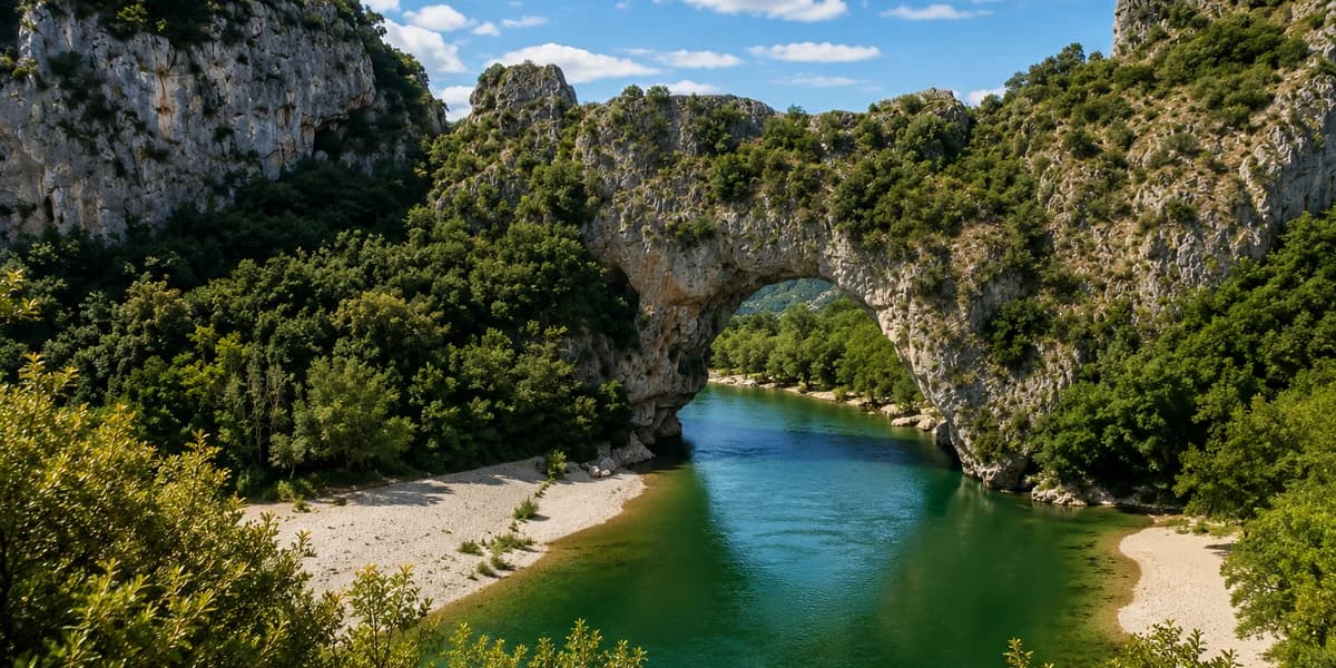
NatureVallon-Pont-d'ArcA 20-mile canyon with 800-foot cliffs, eleven panoramic overlooks, and a 1,950-hectare national nature reserve.

ARDÈCHE
The Bivo Moto community is building the motorcycle accommodation map
Do you know a hotel, guesthouse or campsite suited for motorcycle travelers in this area? Share it and help other riders plan their next road trips.
Recommend an establishmentArdèche is one of those departments that's unlike anything else. Wedged between the Massif Central and the Rhône Valley, it delivers a landscape variety that can surprise even the most seasoned riders: gorges carved into limestone nearly 800 feet deep, wind-swept volcanic plateaus, chestnut forests, and villages perched on basalt outcrops. The terrain is relentless, and so are the roads. There are around forty passes accessible by motorcycle, some of them practically deserted even in July. The season easily stretches from April to October, with May-June and September being the sweet spot to dodge the summer crowds in the south. The north is greener, quieter, almost alpine. The south smells of thyme, garrigue, and cicadas. In between, hundreds of miles of winding back roads just begging to be devoured without any rush. Ardèche rewards those who take the time to get lost in it.
Terrain
Volcanoes → Limestone Gorges
Roads & Passes
~40 passes, 500 miles of back roads
Best Season
April – October
Ardèche is best explored at its own pace, sector by sector. In the south, the Ardèche Gorges are unmissable: 20 miles of canyon with sheer cliff faces, eleven developed overlooks, and the famous Pont d'Arc, a natural arch carved by the river. Just nearby, Chauvet Cave 2 plunges visitors back into prehistory with rock paintings 36,000 years old, listed as a UNESCO World Heritage Site. Aven d'Orgnac, a Grand Site de France, unfolds its massive underground chambers down to 121 meters deep. Character-filled villages are everywhere: Balazuc clinging to its cliff above the river, Vogüé with its Seigneurs' castle, Labeaume nestled among towering limestone cliffs, and Antraigues-sur-Volane perched at 470 meters on its volcanic outcrop. In the north, Tournon-sur-Rhône overlooks the Rhône from its castle, a classified historic monument. Further up, Mont Gerbier-de-Jonc marks the source of the Loire River amid a striking volcanic landscape. Ardèche's gastronomy is also worth a stop: chestnuts, caillette sausage, pélardon cheese, and Rhône Valley wines, best enjoyed at local markets or a small village inn.
A 20-mile canyon with 800-foot cliffs, eleven panoramic overlooks, and a 1,950-hectare national nature reserve.
A natural arch carved by the Ardèche River, the iconic symbol of the department and the gateway to the gorges.
A faithful replica of the world's oldest decorated cave, UNESCO-listed, spread across 3,500 m² of immersive reconstruction.
A Grand Site de France featuring three enormous underground chambers reaching 121 meters deep, with a spectacular sound and light show.
A volcanic dome at 5,089 feet marking the source of the Loire River, with a breathtaking panorama over the Ardèche high plateaus.
A 200-foot waterfall plunging into an ancient lava flow with basalt columns, reachable by a 15-minute walk from the road.
A characterful village clinging to the limestone cliff above the Ardèche River, with medieval alleyways winding through a labyrinth of stone.
A village listed among the most beautiful in France, tucked into a bend of the river with a castle listed as a Historic Monument.
A village perched at 1,540 feet on a volcanic outcrop, the inspiration for singer Jean Ferrat, known for its 100 sculpted lava-stone heads.
A 15 km² forest scattered with petrified limestone boulders in strange shapes, nicknamed the fairy forest by the locals.
A town overlooking the Rhône across from Tain-l'Hermitage, featuring a classified historic monument castle and picturesque cobblestone streets.
A medieval fortress dominating the Ardèche Valley with panoramic views from the top of the tower and a regional museum inside.
A volcanic crater lake at 3,280 feet elevation, covering 90 hectares and reaching 108 meters deep, set in a pristine natural environment.
A charming village nestled along the Beaume River, surrounded by towering limestone cliffs and stone-paved alleyways.
The largest wildlife park in Auvergne-Rhône-Alpes, covering 80 hectares with 900 animals including big cats, bears, and species from around the world.
A former sheepfold in the heart of the gorges showcasing the cultivation and distillation of Ardèche lavender, near Vallon.
A Gallo-Roman city and medieval village with an 11th-century castle, historical exhibits, and a remarkable trompe-l'œil painted on the facade.
A historic steam train running along the Doux Gorges on a cliff-hugging route, with a rail bike option available on the return trip.
Ardèche is one of the rare French departments that offers two radically different riding experiences within just a few dozen miles of each other. In the south, the D290 — known as the "Gorges Road" — is a must-ride: it follows the canyon for 20 miles from Vallon-Pont-d'Arc, delivering jaw-dropping drop views over the river from the overlooks. Head north and into the center, and it's a completely different world — the Monts d'Ardèche and the Regional Natural Park. Small back roads like the D122 toward Antraigues, the D536 toward the Col de la Croix de Bauzon, or the D378 leading up to Mont Gerbier-de-Jonc are earned through relentless corner sequences set in landscapes from another era. The D103 through the Doux Valley or the roads around Saint-Agrève deliver the kind of twisty riding sequences that reward riders who love precise cornering. To link north and south, the D104 via Aubenas is the practical option, but the ridge roads through Largentière or the D24 crossing toward Les Vans are far more satisfying. All in all, a full lap of the department wraps up easily in 500 miles over three days, with overnight stops in Aubenas, Privas, or down south in Lanas.
20 miles of panoramic road towering 650 feet above the canyon, with stops at the Serre de Tourre and Balcon des Templiers overlooks.
A climb up the volcanic dome that marks the Loire's source at 5,089 feet, with twisty roads through near-deserted high plateau scenery off-season.
Crossing the Col de la Croix de Bauzon at 4,311 feet, stringing together fast and slow sweepers with panoramic views over the Monts d'Ardèche.
A stunning road running along the Doux River through forests and cliffs, with cliff-hugging sections and gorge views from the ridgeline.
A southern loop through Largentière, Les Vans, and the Bois de Païolive, mixing narrow forest roads with open views over the vineyards.
The switchback approach to the perched village of Antraigues from Vals-les-Bains, with sweeping views over the Volane and Mas valleys.
Haut-Vivarais roads with back-to-back twisties through chestnut groves, lightly trafficked with generally excellent pavement.
A ridge-road route between Ardèche's two main towns, bypassing the N102 with sweeping views over deep valleys.